
By Brooke Holland
Noozhawk
Santa Barbara County authorities have announced changes to the way evacuation orders will be issued and released a new “risk map” for debris flows after the deadly Jan. 9 storm.
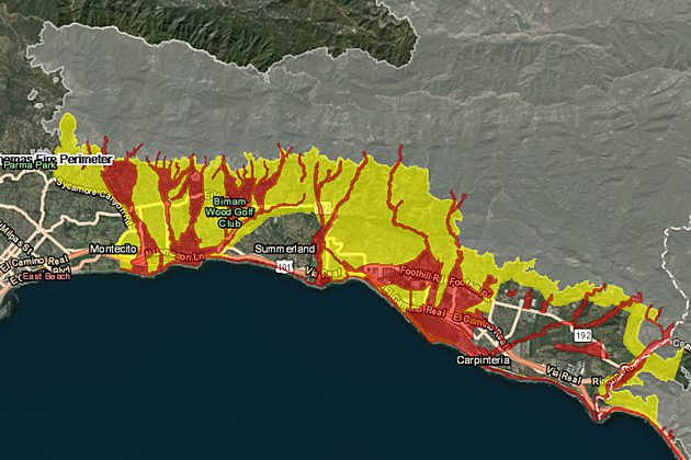
The interactive map outlines areas with an extreme risk or high risk of debris flows in the event of rains that reach half an inch per hour or more, which includes communities below burn scars from the recent Thomas, Alamo, Whittier and Sherpa fires.
With rain falling that heavily on those burn scars, a storm would be capable of producing debris flows similar to the Jan. 9 storm.
The new interactive map and other information are available on Santa Barbara County’s new website, ReadySBC.org.
At a meeting with reporters at Montecito Fire Station 1, Sheriff Bill Brown explained the new evacuation timeline for storms, which starts when the National Weather Service alerts the county Office of Emergency Management 72 hours before a major storm is forecast to arrive.
The timeline as a heavy storm approaches will be:
- 72 hours before the storm: A pre-evacuation advisory is issued by the Sheriff’s Office, meaning community members should begin planning for potential evacuations.
- 48 hours prior: Sheriff’s Office issues a recommended evacuation warning, meaning those with access, functional needs or large animals should evacuate.
- 24 hours prior: Sheriff’s Office issues a mandatory evacuation order, meaning community members in extreme risk and high risk (shown on the new map) should evacuate.
- 12 hours prior: the mandatory evacuation order will become effective, meaning community members in extreme risk and high risk areas should have left the area.
The new plan represents a major change from the evacuation procedure used during wildfires and ahead of the Jan. 9 debris flows, which included mandatory evacuation and voluntary evacuation areas in effect at the same time, for different areas.
“We found after the Jan. 9 event for some people the focus was on the word voluntary, not the word evacuate,” Brown said.
“Our evacuation plans have been refined since the Jan. 9 debris flow,” said Deputy Chief Kevin Taylor of the Montecito Fire Protection District.
In the event of such a heavy storm, Highway 101 will be closed between Santa Barbara and the Carpinteria area as well, California Highway Patrol Commander Cindy Pontes said.
When a pre-evacuation advisory is issued, the CHP, in coordination with the California Department of Transportation, will prepare to close Highway 101 between Milpas Street in Santa Barbara and Highway 150 near Carpinteria, she said.
About two hours before the storm’s anticipated arrival, CHP will begin to shut down Highway 101, and all the on-ramps in both directions within that area, to “keep people out of the high and extreme risk areas,” Pontes said.
“We know this will be a huge inconvenience, however it is necessary to protect lives,” Pontes said.
Emergency officials warned that a storm can occur with limited or no warning, and residents also need to be prepared.
“There could be rare instances where a rogue storm hits our community and causes flash flooding and debris flow with little warning,” Brown said.
The new interactive map of debris flow risk areas and other information is available on Santa Barbara County’s new website, ReadySBC.org.
The color-coded map includes data from the Burn Area Emergency Response team, the California Watershed Emergency Response Team and the state watershed emergency response team, according to Rob Lewin, director of Santa Barbara County’s Office of Emergency Management.
Residents can enter their address in the map to view the risks next to their homes or businesses.
The areas in red are considered at extreme risk of debris flows in the event of rainfall of half an inch per hour or more, authorities said.
The red areas of the map are described this way: “Properties are located in an extreme risk of debris flows from water overtopping the creek banks. Debris flows similar to the Jan. 9 event could occur. If rain is predicted to be a half-inch per hour or more, residents would be ordered to evacuate. Leave immediately and seek shelter in a location outside the evacuation area.”
The yellow areas are considered high risk, which means: “If rain is predicted to be a half-inch per hour or more, you would be at risk from being cut off from utilities including natural gas, potable water, sewer, electricity, cellular phone service and other services for multiple days. Roads may become impassable and even deadly. It’s advised to leave immediately and seek shelter in a location outside the evacuation area.”
Light grey areas on the map show recent burn scars from the Thomas, Alamo, Whittier and Sherpa fires.
The Sheriff’s Office also released new terminology and definitions for evacuations, for both storm-related impacts and wildfires.
The new evacuation timeline will apply only to future storms, however, with different emergency responses for wildland fires, officials said.
Below are the new terms and definitions released by county officials:
- Pre-evacuation advisory: Possible risks to life or property. Residents should immediately start preparations to leave and closely monitor the situation. If at any time you feel threatened, don’t wait for a notification and take immediate action.
- Recommended evacuation warning: Sheriff’s Office strongly urges and recommends those in designated evacuation areas (extreme and high risk) to relocate to safer locations. High risk for loss of property and life. Personal discretion is allowed, but not advised. People with access or functional needs or those with large animals are urged to leave. Take immediate action if you feel threatened, and do not wait for a notification.
- Mandatory evacuation order: Extreme risks for loss of property or life. Sheriff’s Office orders everyone in designated evacuation areas to relocate to safe locations. Personal discretion is not an option. Mandatory evacuation order will apply to the public. Those who refuse to comply with a mandatory evacuation order will not be forcibly removed, but they should not expect rescue or other lifesaving assistance after the onset of the emergency.
County officials also stressed the importance for people to register for emergency alerts through the Aware and Prepare program. Alerts from the Santa Barbara County Office of Emergency Management are also available through Nixle, which includes the option for Spanish-language alerts. Instructions are available at readysbc.org.
County officials held an informational meeting in early February at Montecito Union School’s auditorium, where representatives were on hand to answer questions and explain the future storm risks in Santa Barbara County.
A standing-room-only crowd, with people spilling out into the school’s hallway, received information about the evacuation alerts, the new interactive risk map and debris removal.
A video of the nearly three-hour community meeting is available online at the county’s YouTube channel.
Noozhawk staff writer Brooke Holland can be reached at bholland@noozhawk.com.


