
Star Report
The National Weather Service has issued a Red Flag Warning for the Santa Barbara County Mountains and south coast (zones CAZ252) in effect from 5 p.m. Monday August 29, to 10 a.m. Wednesday August 31.
A Red Flag Warning means that critical fire weather conditions are either occurring now or will shortly. A combination of strong winds, low relative humidity, and warm temperatures can create extreme fire behavior.
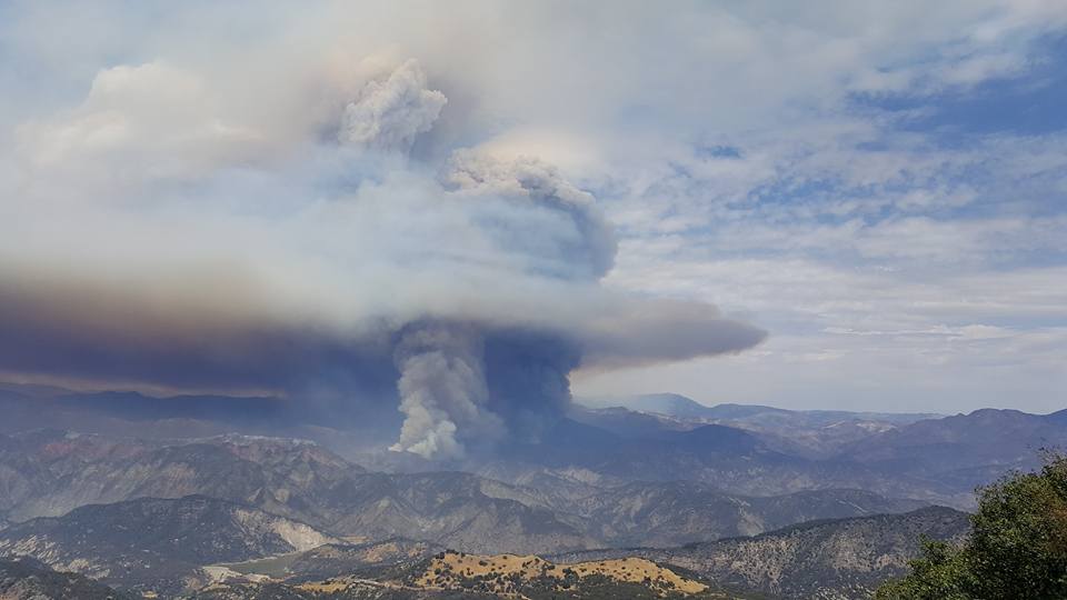
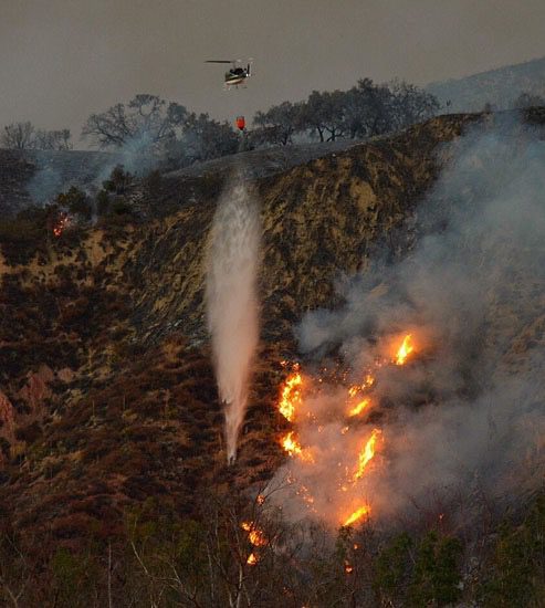
This is especially important for fire crews battling the Rey Fire in the Los Padres National Forest, as they have made significant progress holding the containment lines as it is currently at 33,006, according to fire officials.
The Paradise and Gibraltar Roads are still closed to the public, campers, and anyone not affiliated with the suppression actions. Residents and employees are allowed to utilize the roads for access to their homes or businesses. All additional road closures are still in effect. Highway 154 is open to traffic.
Recycled water from the Santa Ynez Band of Chumash Indians’state-of-the-art tertiary wastewater treatment plant on the Santa Ynez Reservation is helping firefighters in their battle against the Rey Fire.
“When the Tribe was approached about water supply needs, the recycled water from our wastewater treatment plant immediately came to mind, especially since we are experiencing a record-breaking drought period,” said Kenneth Kahn, Tribal Chairman for the Santa Ynez Band of Chumash Indians. “We are pleased to be able to provide assistance at this crucial time in this firefighting effort.”
1,097 personnel are currently battling the blaze, which is down from more than 1,700 last week. The Rey Fire started just before 3 p.m. on Thursday, August 18, near the White Rock Campgrounds, said Mike Eliason of Santa Barbara County Fire.
Red Flag Warning Details
…RED FLAG WARNING IN EFFECT FROM 5 PM THIS AFTERNOON TO 10 AM PDT WEDNESDAY FOR WIND AND LOW RELATIVE HUMIDITY FOR THE SANTA BARBARA COUNTY MOUNTAINS…
THE NATIONAL WEATHER SERVICE IN LOS ANGELES/OXNARD HAS ISSUED A RED FLAG WARNING FOR WIND AND LOW RELATIVE HUMIDITY…WHICH IS IN EFFECT FROM 5 PM THIS AFTERNOON TO 10 AM PDT WEDNESDAY. THE FIRE WEATHER WATCH IS NO LONGER IN EFFECT.
- * WINDS…NORTH TO NORTHEAST 15 TO 25 MPH WITH GUSTS TO 40 MPH.
- * RELATIVE HUMIDITY…8 TO 15 PERCENT.
- * IMPACTS…IF FIRE IGNITION OCCURS OR FOR EXISTING FIRES… CONDITIONS ARE FAVORABLE FOR EXTREME FIRE BEHAVIOR AND RAPID SPREAD OF WILDFIRE WHICH WOULD THREATEN LIFE AND PROPERTY.PRECAUTIONARY/PREPAREDNESS ACTIONS…
A RED FLAG WARNING MEANS THAT CRITICAL FIRE WEATHER CONDITIONS ARE EITHER OCCURRING NOW…OR WILL SHORTLY. A COMBINATION OF STRONG WINDS…LOW RELATIVE HUMIDITY…AND WARM TEMPERATURES WILL CREATE EXTREME FIRE BEHAVIOR.


